
North Atlantic Oscillation
Seeing the big picture in the Gulf of Maine
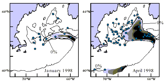
6. Case study: Cold water invades the Gulf of Maine
- A lag can occur before the NAO’s oceanographic shifts show up in the Gulf of Maine.
- In January 1998, for example, the Labrador Current began to enter the Northeast Channel into the Gulf of Maine.
- Eight months later, the Labrador Slope Water had spread throughout the Gulf.
- This event lagged a low NAO index by two years.
 |
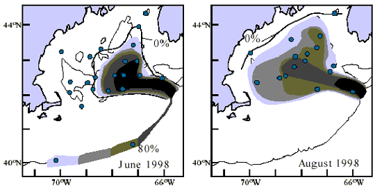 |
These maps show the spread of Labrador Slope Waters (dark
areas) through the Northeast Channel into the Gulf of Maine
in 1998. Located below the ocean surface, the mass of cold
water flowed at depths of 100 to 300 meters. Blue dots indicate
locations of water samples collected from ships. GoMOOS
buoys could provide similar data on a routine basis. |
1.Seeing the big picture: Introduction
2.Offshore buoys are sentinels of change
3.GoMOOS monitors currents entering the Gulf Of Maine
4."El Niño of the Atlantic" affects the incoming currents
5.Warm or cold currents can penetrate the Northeast Channel
6.Case study: Cold water invades the Gulf of Maine
7.Ripple effects reach bays and estuaries
Acknowledgements